


29 Aug How Houston Can Become More Resilient To Future Floods
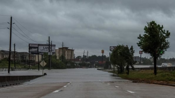
The devastating flood in Houston may be called a “1,000-year flood,” meaning it supposedly has a 1-in-1,000 chance of happening in a given year. But parts of Harris County reached 1,000-year flood levels in another storm in 2016; other parts of the county experienced a “500-year flood.” Another 500-year flood happened in 2015. If you’re 28 and have always lived in Houston, you may have experienced eight “100-year” floods so far in your life.
Smaller but still damaging floods are even more frequent. Some amount of flooding is unavoidable in the low-lying city. But urban planners and designers say future storms that are likely to continue to become more common and more intense because of climate change, and that Houston–and any city with a risk of flooding–has a choice: It can continue dealing with catastrophic flooding or accept that they floods will continue and redesign so that it is resilient to them. The city could both to make future floods less damaging, and to become better able to rebound when floods do happen.
One step the city and county can take is creating new green infrastructure (and protecting the amount that already exists) that can soak up excess rain. The lowest, most vulnerable areas, some argue, shouldn’t be used for housing or other development. “Those should be green spaces,” says Philip Berke, a landscape architecture and urban planning professor at Texas A&M University. “You shouldn’t allow development in those.”
In some cases, as the city recovers from the current floods, it might decide not to rebuild certain areas, perhaps creating parks designed to contain flood waters there instead. In one area in North Houston where a 2016 storm caused particular damage, the city is planning to buy out two low-income apartment complexes so residents can move and the area can be used as a flood basin that doubles as a park.
That plan, in place before Tropical Storm Harvey, is unusual–for years, officials have supported development in low-lying areas because construction has been an engine of economic growth. But it’s also an example of how the city could help particularly vulnerable people: The poorer you are, the more likely you are to suffer damage in a flood, both because cheap housing is more likely to be in a floodplain and because the houses are less likely to be elevated as much as necessary. (Low-income families also struggle to afford insurance coverage or to get payouts when they have it, as adjusters often argue that it’s difficult to determine whether damage came from the disaster or deferred maintenance.)
“One of the findings that is most robust in the disaster literature is that low-income families and families of color will receive a greater degree of damage to begin with,” says Shannon Van Zandt, interim department head of the landscape architecture and urban planning department at Texas A&M. Recovery can take two to four times longer for low-income families or families of color than for other households.
While the city is unlikely to buy up all of the lowest-lying areas, it can build more resilient infrastructure into those neighborhoods–“pervious” pavement that can soak up rain, for example, or bioswales along roads and sidewalks designed to store water. Traditional infrastructure, like drainage pipes that are too small to handle heavy storms, also needs upgrading.
The region could also choose to limit new development in dwindling wetlands and prairies near Houston, which play a critical role in mitigating floods.
“There is still undeveloped land in the western portions of many of our watersheds, and these undeveloped areas contain wetlands and have the capacity to hold large amounts of storm water, with that amount potentially increased with selective use of levees,” Jim Blackburn, co-director of the Severe Storm Prediction, Education, and Evacuation from Disaster Center at Rice University, writes in a prepared statement shared with Fast Company. “The purchase and set aside of these undeveloped tracts must be part of the long-term protection of the Greater Houston region.”
It costs around $500,000 to $1,000,000 an acre to buy out a flood-prone subdivision, Blackburn says. But undeveloped land, even if valuable, can be 10 times cheaper to acquire and then protect. “We don’t need to re-engineer what nature has given us,” he says. “We simply need to find ways to keep it natural and pay the landowners a fair price for the ‘service’ that their lands either are doing or could do for our region.”
Over the past few decades, around three-quarters of those natural areas have been developed, leaving water that could have been absorbed to flow into Houston.
The more development has occured, the larger the floodplain has grown. A floodplain–an area more prone to flooding, typically on low-lying land near water–can expand when development covers areas that would have previously absorbed water. “Part of the issue with Houston is that we don’t really know where the floodplain is right now,” says Van Zandt. Up to 40% of flood claims, she says, have come from outside the floodplain as it’s currently mapped.
If most or all of the city is at risk, designing buildings in the right way is also important. The architecture firm Perkins + Will, which has an office in Houston among its global locations (as far as the company knows, the office is okay, though because roads are impassable no staff have been able to go to work), has a resilience lab that studies how to make buildings and communities more resilient to risks from climate change, including flooding. It also uses a custom rating system to evaluate the resilience of its designs.
At a hospital under construction now in Corpus Christi, a city which was also struck by Harvey, the architects designed oversized roof drains, space for food and water storage for four days, emergency generators that can provide power for five days, hurricane-resistant exterior materials, and other features meant to be resilient in storms. The hospital is also located in a 500-year floodplain; typically, architects design to a 100-year floodplain standard, which made sense historically when risks were lower.
The architects also try to include features in each design to soak up rainwater, such as green roofs and rain gardens. They say the features don’t create much added cost, but if deployed at scale throughout cities like Houston, could make a measurable difference in flooding. They aren’t widely used yet. “I think it would help if there were incentives here locally for developers and owners to implement these strategies in their buildings,” says Cindy Villarreal, who works in the firm’s Houston office.
The city has done some work in flood prevention, designed to keep the water out: The Army Corps of Engineers began work in 2016 to repair two dams north of the city that are rated extremely high risk. Houston has already spent money “re-engineering” the city’s bayous, digging out soil to increase their capacity to hold water (the process is controversial). The region is also considering a massive coastal barrier, the Ike Dike, to protect from storm surges. But many argue that along with investments in more traditional engineering, the area also needs a better approach to land use planning and green infrastructure–and an acknowledgement that the water is coming, no matter what efforts the city undertakes.
“[Houston’s] approach is structural: We’re going to build our way out of it,” says Berke. “We’re going to widen and deepen the bayous, and spend billions doing it. But let them build wherever they want.” Instead, he says, the city should be more proactive in identifying where development should happen, build up green infrastructure, and consider more creative approaches to water storage, like the water-storing parks and parking garages used in cities like Rotterdam.
Residents also need better data–including the real risk that their home will flood as the climate changes–so they can make choices when buying a home or moving elsewhere. “We need better information about what our rainfall future holds for us, and we need to be honest about it,” says Blackburn. “The floodplain maps for the county should be redrawn with new and realistic rainfall amounts.”
Local officials also have to stop denying the climate change is happening and worsening storms. (In a ProPublica article in 2016, Mike Talbott, who was head of Houston’s flood control district for 35 years, said that he didn’t think floods were the “new normal.”)
“State and local governmental employees are afraid to even mention climate change because of the politics–because of fear of losing their jobs,” says Blackburn. “Well, the politics need to be damned if they refuse to recognize a key element of protecting our citizens from current and future flood problems.”
Source: Fast Company
Sorry, the comment form is closed at this time.